http://www.fourcornersgeotourism.com/content/navajo-nation-indian-reservation/fca81F6C25FF21711E54
http://www.mesaverde.com/fcmonument.htm
http://en.wikipedia.org/wiki/Four_Corners_Monument
http://www.arizonaguide.com/places-to-visit/arizona-parks-monuments/four-corners-monument
http://www.utah.com/playgrounds/four_corners.htm
http://en.wikipedia.org/wiki/Four_Corners
It is the only place in the United States and probably in the world where four state entities meet at the same point; to the NW Utah, to the NE Colorado, to the SW Arizona and to the SW New Mexico.
It is thus possible to be in four states at the same time, although that does take a bit of dexterity if one doesn't mind looking a bit silly doing that.
The Navajo Nation is the largest Native American Reservation in the country, (71,000 km2 / 27,425 square miles) in other words covering more square miles than a number of states in the US.
It will take the States of New Hampshire, New Jersey, Connecticut, Delaware and Rhode Island to make up the same area. The Nation is larger than West Virginia and just a bit smaller than South Carolina. It is 1.65 times larger than my home country of Denmark, which has a population density of 336.7 per square mile / 130 per km2. The population density on the Navajo Nation land is at 2.5 per km2. In other words, if you were to live on the Navajo Nation you know you have neighbors, but you may not see them for days.
http://www.discovernavajo.com/
http://en.wikipedia.org/wiki/Navajo_Nation
http://www.navajo-nsn.gov/
http://www.navajonationcouncil.org/
http://en.wikipedia.org/wiki/Navajo_(people)
http://www.ihs.gov/Navajo/index.cfm?module=nao_navajo_nation
http://navajotimes.com/
We arrived early in the day before it got too hot. The landscape is something you will either find serene or rather bleak. This is true SW dessert landscape. There were a lot of people present already visiting the site; so many that each group or family was only giving a little bit of time to take picture.
Considering the absolute "desolation" of the area, dry as "a bone" (see photo below) we found one particular souvenir amusing and we purchased it. (see photos below this one)
Norma at the Four Corners. She is standing with the left foot in Utah
and the right foot in Arizona.
Same place, different perspective.
I strongly recommend using the attached links to read up on the Four Corners National Monument and on the Navajo Nation (reservation) and the Navajo People. There is some very
interesting history about the nation and people in particular.
After buying a souvenir or two we left Four Corners and on the way back to Farmington we stopped in the small community of Teec Nos Pos. It is a small community and if one does not live on the Navajo Nation it probably does not get much business. Here we mailed a postcard to ourselves which was waiting for us when we returned home about 4 or 5 days later.
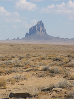
http://teecnospos.navajochapters.org/The last stop was just along the highway to look at Shiprock. Back in the "good old days" when I got out of the army and bummed around in a surplus army tent I spent about 5 days camped in the shade (not much to be had) of Shiprock and I would drive or walk to the nearest trading post for canned food and several quarts of beer (decompression can be so much fun when coupled with absolute solitude). Now there are fences and no way to get there, so we had to settle for a few pictures from the road.
http://en.wikipedia.org/wiki/Shiprock
http://www.lapahie.com/Shiprock_Town.cfm
http://www.americansouthwest.net/new_mexico/shiprock/index.html
http://www.bing.com/places/search?q=Shiprock%2c+New+Mexico&upgid=928135&qpvt=shiprock+&FORM=ATRCCN
The distance from the road, where the picture was taken from, is about 6.5 miles / 10.5 km.
Ship rock received its name from the Spanish explorers that came
through this area and thought that at a great distance it looked like a
Spanish Galleon under sail.
For a close up look of Shiprock go to Google Earth. It stands out in an otherwise mostly flat landscape.
After a nice dinner we rode our bikes along the banks of the river that flows through town. Farming sits at the confluence of the San Juan, La Plata and the Animas river system. We saw several people paddling kayaks, and we understand that this is a great whitewater area.
Tomorrow we leave Farmington, NM and generally head toward home, but not directly, we will go up into Colorado just to say we drove over the Continental Divide at some of the higher elevations.


No comments:
Post a Comment